


Geospatial intelligence and satellite data in defence: the strategic role of open data in Spain


Fecha de la noticia: 16-06-2025

In an increasingly interconnected and complex world, geospatial intelligence (GEOINT) has become an essential tool for defence and security decision-making . The ability to collect, analyse and interpret geospatial data enables armed forces and security agencies to better understand the operational environment, anticipate threats and plan operations more effectively.
In this context, satellite data, classified but also open data, have acquired significant relevance. Programmes such as Copernicus of the European Union provide free and open access to a wide range of Earth observation data, which democratises access to critical information and fosters collaboration between different actors.
This article explores the role of data in geospatial intelligence applied to defence, highlighting its importance, applications and Spain's leadership in this field.
Geospatial intelligence (GEOINT) is a discipline that combines the collection, analysis and interpretation of geospatial data to support decision making in a variety of areas, including defence, security and emergency management. This data may include satellite imagery, remotely sensed information, geographic information system (GIS) data and other sources that provide information on the location and characteristics of the terrain.
In the defence domain, GEOINT enables military analysts and planners to gain a detailed understanding of the operational environment, identify potential threats and plan operations with greater precision. It also facilitates coordination between different units and agencies, improving the effectiveness of joint operations.
Defence application
The integration of open satellite data into geospatial intelligence has significantly expanded defence capabilities. Some of the most relevant applications are presented below:
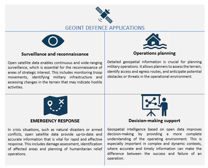
Figure 1. GEOINT applications in defence. Source: own elaboration
Geospatial intelligence not only supports the military in making tactical decisions, but also transforms the way military, surveillance and emergency response operations are planned and executed. Here we present concrete use cases where GEOINT, supported by open satellite data, has had a decisive impact.
Monitoring of military movements in conflicts
Case. Ukraine War (2,022-2,024)
Organisations such as the EU Satellite Centre (SatCen) and NGOs such as the Conflict Intelligence Team have used Sentinel-1 and Sentinel-2 (Copernicus) imagery for the Conflict Intelligence Team :
- Detect concentrations of Russian troops and military equipment.
- Analyse changes to airfields, bases or logistics routes.
- Support independent verification of events on the ground.
This has been key to EU and NATO decision-making, without the need to resort to classified data.
Maritime surveillance and border control
Case. FRONTEX operations in the Mediterranean
GEOINT powered by Sentinel-1 (radar) and Sentinel-3 (optical + altimeter) allows:
- Identify unauthorised vessels, even under cloud cover or at night.
- Integrate alerts with AIS (automatic ship identification system).
- Coordinate rescue and interdiction operations.
Advantage: Sentinel-1's synthetic aperture radar (SAR) can see through clouds, making it ideal for continuous surveillance.
Support to peace missions and humanitarian aid
Case. Earthquake in Syria/Turkey (2,023)
Open data (Sentinel-2, Landsat-8, PlanetScope free after catastrophe) were used for:
- Detect collapsed areas and assess damage.
- Plan safe access routes.
Coordinate camps and resources with military support.
Spain's role
Spain has demonstrated a significant commitment to the development and application of geospatial intelligence in defence.
|
European Union Satellite Centre (SatCen) |
Project Zeus of the Spanish Army |
Participation in European Programmes |
National capacity building |
|
Located in Torrejón de Ardoz, SatCen is a European Union agency that provides geospatial intelligence products and services to support security and defence decision-making. Spain, as host country, plays a central role in SatCen operations.
|
The Spanish Army has launched the Zeus project, a technological initiative that integrates artificial intelligence, 5G networks and satellite data to improve operational capabilities. This project aims to create a tactical combat cloud to enable greater interoperability and efficiency in military operations. |
Spain actively participates in European programmes related to Earth observation and geospatial intelligence, such as Copernicus and MUSIS. In addition, it collaborates in bilateral and multilateral initiatives for satellite capacity building and data sharing. |
At the national level, Spain has invested in the development of its own geospatial intelligence capabilities, including the training of specialised personnel and the acquisition of advanced technologies. These investments reinforce the country's strategic autonomy and its ability to contribute to international operations. |
Figure 2. Table. Own elaboration
Challenges and opportunities
While open satellite data offers many advantages, it also presents certain challenges that need to be addressed to maximise its usefulness in the defence domain.
-
Data quality and resolution: While open data is valuable, it often has limitations in terms of spatial and temporal resolution compared to commercial or classified data. This may affect its applicability in certain operations requiring highly accurate information.
-
Data integration: The integration of data from multiple sources, including open, commercial and classified data, requires systems and processes to ensure interoperability and consistency of information. This involves technical and organisational challenges that must be overcome.
-
Security and confidentiality: The use of open data in defence contexts raises questions about the security and confidentiality of information. It is essential to establish security protocols and measures to protect sensitive information and prevent its misuse.
- Opportunities for collaboration: Despite these challenges, open satellite data offer significant opportunities for collaboration between different actors, including governments, international organisations, the private sector and civil society. Such collaboration can improve the effectiveness of defence operations and contribute to greater global security.
Recommendations for strengthening the use of open data in defence
Based on the above analysis, some key recommendations can be drawn to better exploit the potential of open data:
-
Strengthening open data infrastructures: consolidate national platforms integrating open satellite data for both civilian and military use, with a focus on security and interoperability.
-
Promotion of open geospatial standards (OGC, INSPIRE): Ensure that defence systems integrate international standards that allow the combined use of open and classified sources.
-
Specialised training: foster the development of capabilities in GEOINT analysis with open data, both in the military domain and in collaboration with universities and technology centres.
-
Civil-military cooperation: establish protocols to facilitate the exchange of data between civilian agencies (AEMET, IGN, Civil Protection) and defence actors in crisis or emergency situations.
- Support to R&D&I: to foster research projects exploring the advanced use of open data (e.g. AI applied to Sentinel) with dual applications (civilian and security).
Conclusion
Geospatial intelligence and the use of open satellite data have transformed the way armed forces and security agencies plan and execute their operations. In a context of multidimensional threats and constantly evolving scenarios, having accurate, accessible and up-to-date information is more than an advantage: it is a strategic necessity.
Open data has established itself as a fundamental asset not only because it is free of charge, but also because of its ability to democratise access to critical information, foster transparency and enable new forms of collaboration between military, civilian and scientific actors. In particular:
- Improve the resilience of defence systems by enabling broader, cross-cutting analysis of the operating environment.
- Increase interoperability, as open formats and standards facilitate exchange between countries and agencies.
- They drive innovationby providing startups, research centres and universities with access to quality data that would otherwise be inaccessible.
In this context, Spain has demonstrated a clear commitment to this strategic vision, both through its national institutions and its active role in European programmes such as Copernicus, Galileo and the common defence missions.
Content prepared by Mayte Toscano, Senior Consultant in Data Economy Technologies. The contents and points of view reflected in this publication are the sole responsibility of the author.


